The validation of SWOT data in the Bristol Channel and Severn Estuary, UK, shows that SWOT efficiently captures coastal hydrodynamics, revealing high accuracy in the measurement of water level across diverse tidal conditions. With appropriate filtering and processing strategies, SWOT data are suitable for many applications of societal relevance.
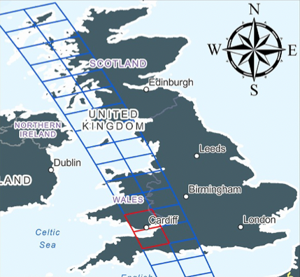
The paper “Evaluating SWOT in the Coastal Zone: Comparisons With Tide Gauge and Airborne LiDAR in the Bristol Channel and Severn Estuary, UK” published on Geophysical Research Letters presents the first validation of SWOT data in a coastal environment using concurrent LiDAR, tide gauge, and pressure gauge across the Cal/Val phase in March – July 2023.
The Bristol Channel and Severn Estuary, located in the southwestern of the UK, form a large macro‐tidal estuary with the world’s second‐largest tidal range (∼14 m). The channel is characterized by complex physical processes, that derive from the interaction of tides, atmospheric forcing and coastal river discharge.
During SWOT 1-day repeat orbit, in addition to four permanent tide gauges part of the Bristol Channel monitoring network, two additional gauges were installed in the channel to complement water surface elevation (WSE) measurements and two pressure gauges were deployed offshore to capture instantaneous Sea Surface Height (SSH) measurements. Five airborne LiDAR surveys were carried out collecting high-accuracy WSE measurements coincident with SWOT overpasses on orbit 42.
The full spectrum of tidal variations effectively captured by SWOT
The comparison of measurements of Total Water Level carried out by tide gauges and pressure gauges with those carried out by the SWOT satellite confirms SWOT’s ability to capture the full spectrum of tidal variations with accuracy comparable to in situ measurements. SWOT maintained a consistent small bias throughout the tidal range (4-12 m) and with differences with in situ measurements of just 13 cm?]
“SWOT data have proven highly correlated with in-situ data, showing near 1:1 relationships. Comparisons between Level 3 LR Unsmoothed data and tide gauges showed a Root Mean Square (RMS) difference of just 13 cm in this region. This should be seen in the context of one of the highest tidal ranges in the world, and the fact that the SWOT data selected for comparison would have had to avoid the exact gauge sites due to land contamination in the pixels closest to the gauges, so will inherently be centred on a slightly different location to the exact gauge coordinates”says Paul Bell, co-author of the paper, Principal Research Scientist at the National Oceanography Center (NOC), UK, and Project Lead of the SWOT AdAC campaign SWOT UK: Bristol Channel and Severn Estuary
Land-based gauges may also experience site-specific effects that are not present in open water such as localised set-up and river influences. Bell explains that remaining noise or discrepancies between SWOT and in-situ data are generally within the bounds of a combination of gauge measurement error and known small amplitude SWOT errors, possibly originating in the crossover correction.
“This performance is notable in particular for its consistency. Tide gauge technology in theory should out-perform SWOT at individual locations, but the harsh reality of real-world port environments can introduce a wide range of additional challenges and uncertainties including mounting and levelling inaccuracies, occasional physical damage and longer term degradation. SWOT brings a consistent and independent measurement of water level that allows us to compare observations across multiple systems in different locations and flag inconsistencies” says Bell.
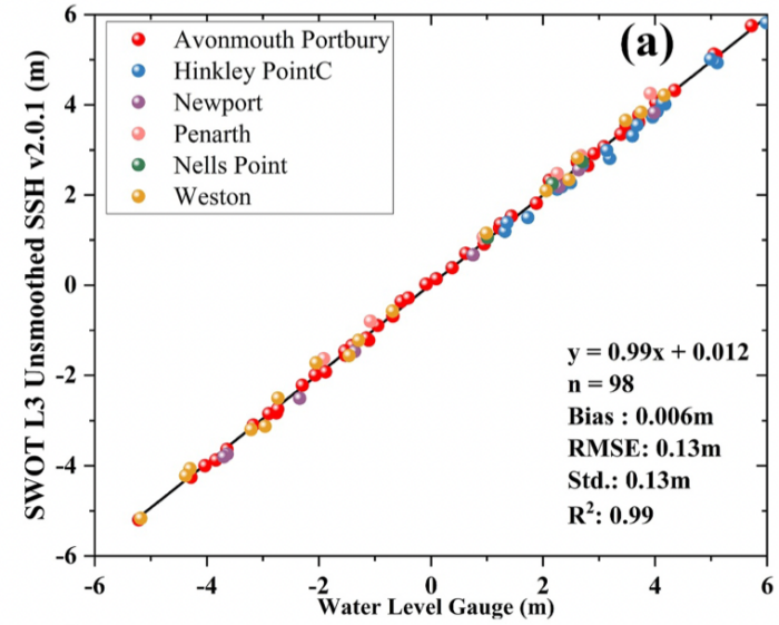
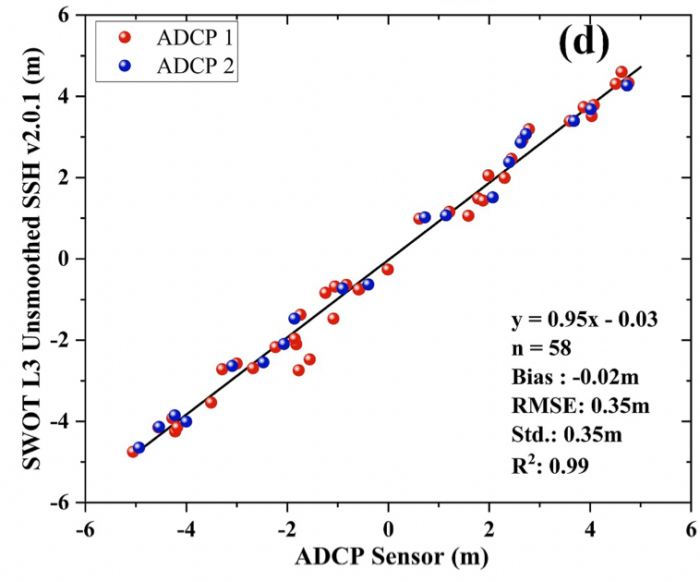
Evaluation of SWOT monitoring capabilities of coastal water dynamics. (a) SWOT‐derived water surface elevation (WSE) compared with tide gauge data. (d) SWOT‐derived WSE compared with ADCP‐mounted pressure sensor data. Credits: Rong et al. 2026
Accurately resolving spatial variability in water surface elevation previously inaccessible to satellites
Comparison of SWOT data with LiDAR data – both pixel and raster – confirms the reliability of SWOT data in accurately resolving spatial variability in water surface elevation in the Bristol Channel, a location where spatial variability in water surface elevation is particularly difficult to resolve. “The Bristol Channel is a particularly challenging environment for standard tidal observations. The strong currents and mobile seabed make vessel-deployed systems a challenge to deploy and result in a significant risk of instrument loss. Tide gauges are also not a perfect solution as almost the only areas with waterside infrastructure that experience the full tidal range are the ports – two of which are located at river mouths (Avonmouth & Newport), so may exhibit some intermittent river influence on their water levels. Everywhere else is either intertidal or lacks infrastructure on which conventional tide gauges could be mounted. SWOT gives us the ability to observe the whole estuary and understand the complex interactions around the intertidal sandbanks, rivers and extreme >14m tides” explains Bell.
Deriving full tidal curves for locations that lack in-situ data and cross-validating in-situ tide gauge outputs
The study confirms that SWOT exhibits viable capabilities for coastal WSE monitoring, with accuracy suitable for many applications when appropriate filtering and processing strategies are applied. Researchers at NOC are already applying SWOT in combination with nearby tide gauge data to deriving the full tidal curves at arbitrary locations within SWOT swaths spanning estuaries and other challenging areas that typically lack in-situ data. They have also begun using the SWOT data to cross-validate in-situ tide gauge outputs, where the consistent accuracy of the SWOT elevation data are allowing inconsistencies with in-situ gauge measurements to be flagged for further investigation. For example, SWOT data have already helped to identify an undiagnosed tilt of over 10 degrees in a radar tide gauge meant to be mounted vertically on a remote platform, leading to incorrect tidal amplitudes due to the ‘slant-range’ of the gauge’s radar beam and an offset in vertical reference.
Another application of SWOT data relates to the connection between marine and terrestrial mapping. “The present generation of mean sea surface maps can misrepresent mean sea surface elevations in coastal areas due to altimetry signal contamination close to the coast, leading to problems relating marine and terrestrial vertical elevations around coasts and estuaries. In the future we expect that SWOT’s remarkable leap in spatial resolution compared with historic altimetry, and now coupled with the added bonus of it’s emerging capability to directly map the elevation of intertidal areas will enable better alignment between the vertical references used between terrestrial and marine mapping” says Bell.
Citation: Evaluating SWOT in the Coastal Zone: Comparisons With Tide Gauge and Airborne LiDAR in the Bristol Channel and Severn Estuary, UK
Rong, Y., Bates, P., Neal, J., Bell, P., Gommenginger, C., Lichtman, I. D., et al. (2026). Evaluating SWOT in the coastal zone: Comparisons with tide gauge and airborne LiDAR in the Bristol Channel and Severn Estuary, UK. Geophysical Research Letters, 53, e2025GL116590. https://doi.org/10.1029/2025GL116590
Contact: Paul Bates (paul.bates@bristol.ac.uk)
Other relevant papers on SWOT capabilities on intertidal environments:
- Lichtman I.D. Et al, 2024, “Evaluating Water Levels From the Surface Water and Ocean Topography (SWOT) Mission in a Hyper-Tidal Coastal and Estuarine Environment”, https://agupubs.onlinelibrary.wiley.com/doi/10.1029/2024EA004104
- Salameh E. et al., 2024, “Evaluating SWOT’s interferometric capabilities for mapping intertidal topography” https://www.sciencedirect.com/science/article/pii/S0034425724004279
- Sun M. Et al., “Deriving Intertidal Topography From SWOT Data and Sentinel-2 Data”, https://agupubs.onlinelibrary.wiley.com/doi/10.1029/2025GL117329?af=R
